Geographical Map
About Pondicherry
The Union Territory of Puducherry comprises the former French establishments
of Puducherry, Karaikal,
Mahe and Yanam, which lie scattered in South India. Puducherry, the capital of the Territory
was once the original headquarters of the French in India, is situated on the Coromandel
Coast of the
Bay of Bengal and is about 135 kms. from Chennai. The Union
Territory with legislature
extends
over
an
area of 490 Sq.
Kms (includes Puducherry, Karaikal, Mahe &Yanam). The Union
Territory of
Puducherry
comprises of
two
distinct
districts of
Puducherry and Karaikal. Puducherry districts comprises of Puducherry region and two outlying
administrative units of Mahe and Yanam. All the four areas of UT of Puducherry are unconnected. All the
four areas bear a strong resemblance of the colonial French rule of the ancient times
|
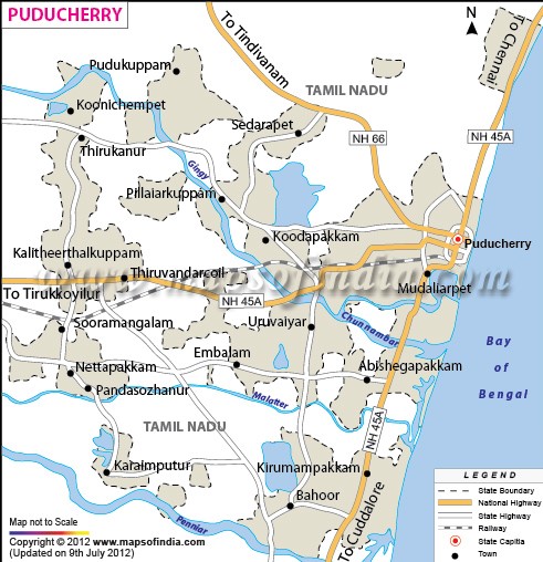
Puducherry: Total area: 290 Sq. Kms. Puducherry is bounded
on Tamil Nadu on it South, North and West side and on the East by Bay of Bengal. Some pockets are
Puducherry is totally surrounded by Tamil Nadu. The region is a flat country of average
elevation of about 15 metres above sea – level,
intersected
by
the deltaic channels of River Gingee and the Ponnaiyar
and other streams
forming the
main drainage basins, interspersed
with lagoons, lakes and tanks. The coastal border has a length of 22Km, with a breadth ranging from four
to
six hundred metres. Superficially, the coast is flat and sandy. |
|
|
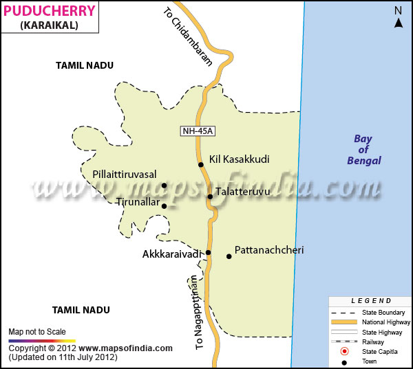
Karaikal: Karaikal District
occupies an area of 157 square kilometres (61 sq miles approx.). Karaikal
town which is situated 16 km. north of Nagappattinam and 12 km. south of
Tharangambadi is the regional headquarters. Karaikal region is made up of the
Municipality of Karaikal, and Communies of Neravy, Tirumalairajanpattinam,
Thirunallar, Nedungadu and Kottucherry. Forming part of fertile delta, the
Karaikal region is completely covered by the distributaries of Cauvery River.
Covered completely by a thick mantle of alluvium of variable thickness, the
region is flat having gentle slope towards Bay of Bengal in the east. It is
limited on the north by the Nandalar and on the south east by the Vettar. |
|
|
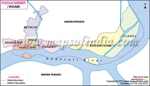
Yanam: Total area: 20 Sq. Kms. Yanam is surrounded by East Godavari district of Andhra Pradesh. The region is bounded on the East and South by River Godavari which discharges itself into the Bay of Bengal after flowing about 14 Km. towards South – east. The town of Yanam is located at a
spot
where the River Coringa and the Godavari separate to divide the region in two parts, one on the east and the other on the west.
The entire
region
is
composed of a flat, monotonous
terrain
without any distinct topographical feature. |
|
|
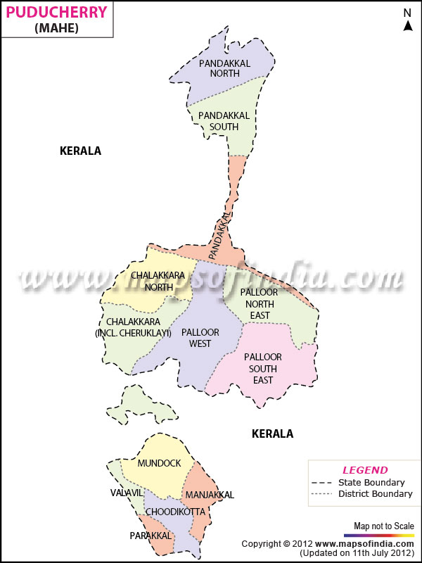
Mahe:
Total area: 8.69 Sq. Kms. The total
area of Mahe
is surrounded by North Malabar of Kerala state.
Mahe is a small area bounded on the South – west by Arabian Sea, on the North by the River Ponniyam (Moolakadavu) and on the other sides by a stretch of Calcareous hills of medium height which are linked to the ghats by a series of wooded hillocks. The River Mahe which flows towards the west
divides the region into two parts. |
|
Links to be linked with
respective District Map: